Details
Currently Full
Date: 26 January – 30 January
Departs from: Auckland
Ends: Wellington
Leaders: : Ian Fuller (Massey), Jon Tunnicliffe (Auckland), Mark Dickson (Auckland), Will Conley (WSP)
Cost ($NZD inc 15% GST):
Shared Accommodation $2,000 per person
Private Accommodation $2,500 per person
Accommodation: 4 nights’ accommodation (26 Jan Hicks Bay, 27 & 28 Jan Gisborne, 29 Jan Napier)
Fitness and field expectations: Some walking over rough terrain (e.g. riverbeds), requiring moderate level of fitness (participants should be comfortable walking up to ~ 8 km)
What to bring:
- Hiking shoes or light hiking boots
- Wet weather gear (i.e. for torrential rain!)
- Warm clothing
- Sun protection (sunhat, sunscreen – essential)
- Walking pole if you usually use when hiking
- Personal medication
- Insect repellent
- Toiletries etc
Day 1
Date: Monday 26 Jan
Location: Auckland to Hicks Bay
Drive Time: 6 ½ hr
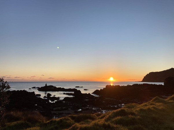
Starting from Auckland airport at 9.00 am we drive south into the Waikato Plains, which have been built by the Waikato River fed by material sourced in the Taupo Volcanic Zone (TVZ). Heading east across the northern margin of the TVZ we will pause at the eastern segment near the Rangitaiki River and discuss the volcanic influences on rivers and coastlines in this region, as well as the challenges this volcanic legacy presents for river management. The drive on to Hicks Bay skirts the northern end of the North Island axial ranges, where the mountains of the Raukumara meet the sea.
Day 2
Date: Tuesday 27 Jan
Location: Jan Hicks Bay to Gisborne via Tapuaeroa and Raparaparaririki
Drive Time: 3 ½ hr
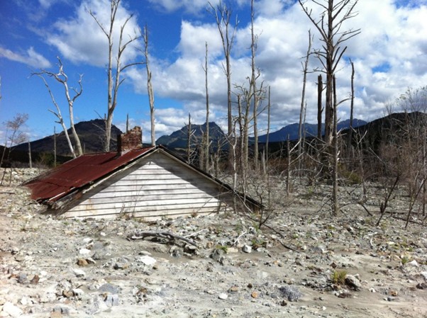
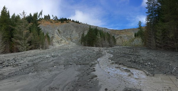
Driving south into the Waiapu catchment (ssy 20,577 t/km2/yr), we discuss catchment erosion, accelerated river aggradation and landscape response to deforestation and storm events, and introduce badass gullies. Onward travel south to Gisborne will incorporate stops in the Mangahauini Gorge (Tokomaru Bay), Uawa River (Tolaga Bay) and Waimata to discuss landscape management (forestry and slash), particularly in the aftermath of Cyclones Gabrielle and Hale (February 2023).
Day 3
Date: Wednesday 28 Jan
Location: Waipaoa
Drive Time: 2 hr
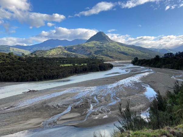
We will work our way up the Waipaoa catchment at a leisurely pace, discussing Holocene and late Pleistocene histories, modern floodplain evolution and sedimentation, a range of sediment generating processes including landslides earthflows and gullies; and landscape and river responses to sediment overload in this catchment, which is quite distinctive from systems visited on Day 2. If conditions allow we will aim to reach the catchment divide before returning to our accommodation in Gisborne, which is by the beach.
Day 4
Date: Thursday 29 Jan
Location: Gisborne to Napier via Mahia
Drive Time: 4 hr
Driving south into Hawkes Bay we will be joined by Prof. Mark Dickson to discuss marine terraces and rock platforms at Mahia Peninsula and then continue via the Mohaka River and Lake Tutira, which is a landslide dammed lake whose cores have yielded high resolution lacustrine records of storminess and ENSO. As we approach Napier we will consider the River Esk response to Cyclone Gabrielle and if there is time pause at Ahuriri Lagoon to reflect on landscape response to the 1933 Napier earthquake.
Day 5
Date: Friday 30 Jan
Location: Napier to Wellington via Wairarapa
Drive Time: 4 hr
Driving south via the Ngaruroro River, we’ll consider management of this actively braided system and the impacts of Cyclone Gabrielle before heading along fringes of the Ruahine Ranges across the Takapau Plains and into the upper Manawatu catchment. Our focus will be farther south in the Wairarapa and the Ruamahanga catchment where fluviotectonics and river management take our interest. We enter Wellington over the Rimutaka Range and along the Hutt Valley and Wellington Fault trace. We will aim to be in Wellington in the early evening.
Participants will need to arrange their own accommodation for Friday night.
Other Field Trips
Geomorphology of the New Zealand Southern Alps
Full
Date: 7 February – 12 February (with option to end in Queenstown on 9 February)
Departs from: Christchurch
Ends: Queenstown on 9 February or Christchurch on 12 February
Cost ($NZD inc 15% GST):
3 days shared accommodation $1300 per person
3 days private accommodation $1600 per person
6 days shared accommodation $2250 per person
6 days private accommodation $2900 per person
Walking Tour of Kaikōura Peninsula Tectonics and Rock Coasts
Full
Date: Wednesday 4 February
Departs from: Christchurch
Ends: Christchurch
Cost ($NZD inc 15% GST): $100 per person
Seismically-Induced Landscape Evolution and Environmental Impacts in Ōtautahi Christchurch
Date: Wednesday 4 February
Departs from: Christchurch
Ends: Christchurch
Cost ($NZD inc 15% GST): $60 per person
River geomorphology and management in a Canterbury braided river: A tour of the Waimakariri catchment
Full
Date: Wednesday 4 February
Departs from: Christchurch
Ends: Christchurch
Cost ($NZD inc 15% GST): $120 per person
Landscape Layers of Te Pātaka-o-Rākaihautū Banks Peninsula: Volcanic and soil geomorphology and their connections to place
Full
Date: Wednesday 4 February
Departs from: Christchurch
Ends: Christchurch
Cost ($NZD inc 15% GST): $150 per person
Glacial Geomorphology of the Waimakariri Valley in Canterbury
Full
Date: Wednesday 4 February
Departs from: Christchurch
Ends: Christchurch
Cost ($NZD inc 15% GST): $85 per person
Engineering Geomorphology and Alpine Hazards Around Arthur’s Pass, Southern Alps
Full
Date: Wednesday 4 February
Departs from: Christchurch
Ends: Christchurch
Cost ($NZD inc 15% GST): $105 per person
Earthquake Faulting and the Leader River Landslide Dam
Full
Date: Wednesday 4 February
Departs from: Christchurch
Ends: Christchurch
Cost ($NZD inc 15% GST): $75 per person
Coastal Geomorphology of the Northern Canterbury Coastline
Full
Date: Wednesday 4 February
Departs from: Christchurch
Ends: Christchurch
Cost ($NZD inc 15% GST): $115 per person
Active Geomorphology from Marlborough to Canterbury – How Faults, Landslides and Sediment Cascades have Shaped Contrasting Landscapes
Full
Date: 31 January – 1 February
Departs from: Wellington
Ends: Christchurch
Cost ($NZD inc 15% GST):
Shared Accommodation $650 per person
Private Accommodation per person $780 per person